Three Peaks
- Anna Hughes

- Oct 31, 2025
- 11 min read
In July 2021 I cycled the Three Peaks with my brother-in-law. When I say that, people think I mean cycling up the mountains. But Three Peaks by Bike means hiking up the highest peaks in England, Scotland and Wales, and riding between each of them.
It's 450 miles with 15,000ft of climbing.
We spent a week on the journey: Day 1, up and down Snowdon, cycle to Denbigh. Day 2 + 3, cycle to Keswick. Day 4, climb Scafell Pike, cycle to Gretna Green. Day 5&6, cycle to Glen Coe. Day 7, cycle to Fort William and climb Ben Nevis.
It was exceptionally hard, but also absolutely brilliant. Here is the story.
This is not the easiest road I’ve ever ridden: it’s partway through being resurfaced and is rough with rubble. Marbles of sticky tarmac cling to our tyres then fling into the air as we ride. There are stones everywhere. What bad luck it would be to slip or get a puncture: it’s only day one, only a few miles in. These are the nerves that come with starting a big ride: is there any way we can make it all the way to Fort William?
Eventually we are back on smooth tarmac and start to come off the pass. They said the road would tip over the edge and follow the gorge downhill for 10 miles. I can’t believe that it will – there are always uphills as well as downs. But 10 miles later we are still freewheeling, and when we reach Betws-y-Coed we stop to eat and paddle in the water that piles over rocks and pours sideways into pools.
It was many months ago that James, my brother-in-law, mentioned the prospect of doing the Three Peaks Challenge by bike. A few years previously he and some friends had completed the 24-hour version, with my sister Sarah driving, and for some reason he wanted to have another pop at it, but this time adding a 400-odd mile bike ride to the mix. Separately, I had had the same idea, after hearing of some others who had ridden it. We teamed up, and conversations turned into plans, and when lockdown restrictions lifted enough we packed our tents into bags and our bikes onto trains and came up here, to Snowdonia.
The days will be long: either on the road or climbing a mountain by 7am, 50 miles of riding on climbing days, 90 miles on non-climbing days. It will take three days to reach Scafell Pike from Snowdon, and another three to reach Fort William and Ben Nevis. We have booked campsites and made a note of where the supermarkets are, because we can’t leave anything to chance.
Snowdon this morning felt good – a fast ascent, less than two hours, with the clouds clearing in time for us to summit. Walking up mountains is new for me, so it’s good to know all those preparatory squats have paid off. Now we are heading for the border, away from Snowdonia National Park and up over the moorland passes to reach our evening campsite where, bellies heavy from a curry and legs heavy from the climb, we will pitch our tents on a soft patch of grass as a hot air balloon lifts into the sky.
*****
It’s a sharp descent from the Flintshire hills to the Dee estuary where we will cross the border. I see the flash of a cycle route sign pointing towards the park, and it’s preferable to this road, so I follow where the sign appears to be indicating, into an open grassy area with precipitous woods in the distance. ‘I think it’s this way, James!’ The surface worsens on a steep downhill slope, and the grass is still wet with morning dew, and suddenly I’m tumbling and my bike is skidding down the hill without me. I don’t know how but instinct tucks my shoulder underneath and safely rolls me over, and I come to a rest flat on my back. James is quickly there, helping me up, gathering my bags. This is definitely not the right way.
Free refills of sugary tea in the Wetherspoons in Shotton helps soothe the adrenaline spike. Then we’re off again, over the railway and river and up towards the Wirral. The border lies partway up the mud flats on the north side of the Dee, rather than straight down the river itself, which I’ve always thought would make more sense, but I’m not in charge of these things. There’s no road access onto the marshes, just the National Cycle Network route which alternates between wooden boards and concrete paths. It’s very flat with lots of grass and scrub and frequent warnings about how dangerous it all is. The blue shadows of the Flintshire mountains watch our rumbling progress from across the estuary. The signpost welcoming us to England is very small, and there isn’t even a red dragon on the other side to reciprocate for Wales.
*****
We are tired of the A6 and its traffic and its terrible cycle lane. It’s been with us since Preston, yesterday, the most obvious route northwards and the one recommended by Google Maps through virtue of the little painted line. But there’s not much space for us and all this traffic on the single-carriageway road. There are hills to our left, hills with stone cottages and sheep and views over the Lune valley so even though we feel each contour line like weights in our legs, that is where we go.
It’s calm up here, with space to breathe. Through Nether Kellet, then Over Kellet, then over a crossroads where a large oak tree offers shade for a quick snack. The farmer’s gate next to the tree interrupts the tall line of the hedge, and we can see, across the field, down over the hills, the sliver of Morecambe Bay pouring like mercury into the land.
There’s no escaping the A591 so we are resigned to its traffic after leaving Windermere. This part doesn’t even have a cycle lane. That stretch into Windermere was punishing: high winds and rain meant hoods were up and eyes were down. At Ambleside the rain stopped but the traffic didn’t, so this last stretch is a misery-push into Keswick.
But then, at Thirlmere, a road sneaks off to the side, cutting the opposite path to the A road on the other side of the lake, and we have instant peace. Hills to our left, vertiginous, then rock faces, then the stampede of a brook streaming almost vertically from the sky. To our right the water, far below, strobing behind tall, thin trunks of pines. Every so often a clearing offers more of a view: a deep, blue jewel of a lake. There is next to no traffic on this road, and a post-rain calm. At the barrage at the far end we stop for some Kendal mint cake.
Keswick isn’t far now: this will be our base for climbing Scafell Pike tomorrow, where we can leave our tents and bags while we go up and down the mountain on what looks like will be an extremely misty and rainy day.
*****
I promised James it would be downhill after this turn: all downhill, even the uphills. But each turn just brings another uphill stretch. ‘All downhill is it?’ he says, and I fret and ride ahead as though I can bring the downhill faster.
I was so sure that this would be the point where we could finally stop pushing. I came along this road on my LEJOG ride, and I remember it clearly, every part, the Forestry Commission car park off the A road, the twisting ascents and descents circling Skiddaw, the emergence onto the Uldale Commons where the long, straight road cuts the plain in half, and where grass and gorse are trimmed by the wind, and where the sky is as wide as it is possible to be. I remember this final ridge, where the road edges skyward in a series of right-angled turns. I remember the view from the top out across Carlisle with the Solway firth and the mass of Scotland beyond, and behind, the peaks of the Lake District, already in retreat, grey and indistinct. But I must have misremembered quite how many hairpins there were, or exactly where that view would emerge, or just how exhausting it can be to ride up, up, up for hours.
The climb this morning was predictably tough, the visibility so poor on Scafell Pike that each cairn only emerged when we had reached the previous one, which, I suppose, is why they’re there. It had been a nine-mile ride there from Keswick, then it was a long nine mile return in the rain, when we were already soaked, cold and humourless from the mountain climb. At least there were dry clothes waiting for us where we’d left the tents, and then, blessed relief! By the time we’d finished our double lunch the rain had stopped falling. Riding out of Keswick I almost cried in gratitude. But that boost is fading now. It has been a long, hard day, with three long, hard days already behind and two still ahead.
And then there it is, the crest, that view, and the descent is extreme, the road straight and rapid, and there are uphills but the downs are enough to push you over each one, and it undulates and goes down and flows and rollercoasters and the pedals need only the lightest of touches for a full six miles and at the end James turns to me and says, I understand now why you promised so much from that road.
*****
The second border crossing is much more obvious than the first: Scotland welcomes us with a large blue thistle on a large brown sign, and everything around screams ‘border’. There’s the first/last house in Scotland, the first marriage shop, the first pub, the first restaurant. It’s a much more significant place than the mud flats on the Welsh border of course, the place where young lovers from England would elope to be married, because Scottish laws would allow it whereas the English would not.
We prop our bikes against the sign for a photograph. The late sun eyes them with an orange stare and I phone the campsite to say we’ll be late, please don’t lock the doors. We are exhausted. Just a few more miles, then we can stop riding and eat our picnic and take our shoes off and at last collapse into our sleeping bags.
*****
From Gretna Green to Larkhall on the outskirts of Glasgow, for 70 miles, the B road wraps itself around the motorway, snaking and criss-crossing, almost always within sight and sound of the traffic rush. This is one of the reasons that this part of the route is renowned among cyclists, and not in a good way. There are few route options once you get to this point, so this is the NCN, the main route north. There’s a sign at one roundabout that simply says ‘north’ one way and ‘south’ the other.
It’s as flat as you might imagine for following the gorge, except it subtly climbs and climbs and climbs, an energy-sapping, endless drag. The view becomes tired after a while, the slow curves of the road offering little to draw the eye. Most of the time there’s not much traffic but there are occasional busy stretches, so a parallel path has been lain for cyclists. The surface is terrible. A slow, never-ending uphill with motorway noise as a backdrop and added vibration. Surely an icon of the cycle network.
At Moffat we leave the route for some respite and some lunch, and the re-join point brings us over the lip of a hill where we can see how spectacular the route is, after all. The whole gorge is laid out below: the gently twisting and turning river, the flood plains at the bottom, the railway partway up the cliff, then the motorway, then our little road cut like a shelf into the side.
*****
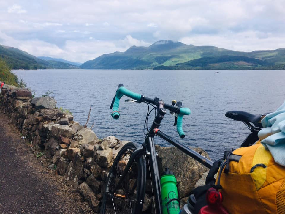
Loch Lomond is large and deep and very blue, and we have it all to ourselves. At least, that’s how it feels, riding along the loch-side road, closed to all vehicles apart from bicycles. ‘That’s a dangerous stretch!’ we had been told time and time again of the Highland route north of Glasgow, but they don’t realise we don’t have to ride on the busy A82, with the bouncing trucks and the camper vans and the cars, there’s a cycle route. Sometimes on the path, or along a parallel road through a village, or down here, on the old road at the bottom of the cliff right next to the water.
It’s hard to imagine that once upon a time all that traffic would have come this way, winding slowly along the narrow road, perhaps nervous about ending up in the loch. Now, the road noise is a mere background to birdsong and the wash of the water. The tarmac is scarred at the edges where nature tries to claim back the territory, and fallen fruit from bramble bushes stains the road with large purple drops. The vista changes subtly each time the route arrives back on the banks, and each view sticks with you. Travelling at 10mph along the banks of Loch Lomond is the way to do it.
This is the longest and potentially hardest day yet. I couldn’t decide if the riding days would be harder than the days when we were climbing as well as riding. The climbs shift the pace and give a different focus, and bring their own mini sense of accomplishment – but once you’re off the mountain there are still 50 miles to ride. At least riding all day means you can get going early and have done 50 miles by lunchtime. But then 80 or 90 miles in total is brutal.
This is also the most challenging day logistically: there’s a pub near the campsite, which stops serving food at 7, so we’d have to have a really good day to make it there in time. The campsite reception closes at 8, and depending on how things go, we might not even get there for that. The last supermarket where we can stock up is at Dumbarton, 75 miles shy of our ultimate destination. So we’ll be carrying food for 75 miles. Not just 75 miles, but 75 very challenging miles: up and through the pass of Glen Coe.
*****
For some reason it was the climb I feared the most, even though the hills in Wales were longer and steeper, and the stretches alongside the M74 more bleak. There’s just something legendary about Glencoe – it’s a proper mountain pass, with a ski station at the top and monoliths all around. I’d crossed it once before, when riding from Lands End to John o’ Groats, and I remembered it being really tough.
‘What do you reckon, an hour to the top?’ We’ve taken a quick break by Loch Tulla, where we can see hairpins scarring the road ahead. Twenty minutes later we’re at the top, laughing. ‘That was… easy! Was that it?’ Of course that’s not it, and we know it, but the hairpins are over and we’re on the plateau, and even though it undulates and kicks and we still have to push against the road, we’re here, passing between the shoulders of mountains.
James has fallen behind and I wait in a layby, feeling like an ant among these giants. ‘You OK?’ He catches up, looking out across the landscape, cheeks blown out. ‘Yeah. This is immense. I had to take a moment.’ It’s an emotional day for him: James has Glencoe in his bones, his beloved granny living on the Ardnamurchan peninsula, so on family trips they would drive the pass and cross to Strontium on the ferry. It has been a dream of his to cycle over the pass for many years, and now he is.
An uphill section, a gentle turn, then the road drops away and there’s a loch and mountains upon mountains upon mountains. A sign says, Welcome to the Highlands. We prop our bikes against it for a photo, the day bright, the sky clear. What a place. The emotion has bitten me too.
It’s another hour until the descent comes, and we both nearly crash – me from hitting the brakes too hard because the views are too good not to take a photo, the momentum nearly taking me over the barrier, and James from realising I’m nowhere to be seen and slamming on his own brakes, the momentum nearly taking him over the barrier. The sky is still blue but it’s hazy now with the evening, the edges of the mountains bleeding into the landscape. A headwind has arrived unannounced so we are pedalling downhill for the final part, frustrated but still smiling.
A sign marked ‘camping’ shows our turn, on a narrow road next to a shallow river which ripples clear and gentle over pebbles, and we have done it: we’re at the campsite before it closes, and we’re at the pub while there’s still hot food, and tomorrow is the final day. It will be an easy 20 miles to Fort William and Ben Nevis in the morning, and we’ll climb on pure adrenaline, and there will be a view from the top, and we will be overwhelmed with it all.
Someone at the pub had passed us in a car earlier in the day and notices the bikes. ‘Why do you do that to yourselves?’ There are many things to say in response: why would you drive and miss the experience, and isn’t it strange that drivers think cycling must be so hard and punishing, and has she seen how wonderful the weather is? I don’t say any of these things, I just smile, and once she’s gone I turn to James. ‘I think what she means is, “well done”.’


Khi xem qua trang chủ cm88 , tôi quan tâm đến phần giao dịch hơn là chỉ nhìn số lượng mục hiển thị trên hệ thống. Những thông tin được trình bày tương đối rõ tạo cảm giác khá thuận tiện khi theo dõi, tôi cũng thấy thao tác nhìn chung khá nhẹ nhàng.
Khi tôi quan sát ở nhiều phiên truy cập khác nhau, cm 88 thể hiện cách tổ chức nội dung theo từng nhóm riêng như live casino, game bài 3D và xổ số. Tôi thấy giao diện được sắp xếp hợp lý giúp việc theo dõi nội dung trở nên dễ hơn trong quá trình sử dụng kéo dài
Việc có thể tìm nhanh đúng nội dung mình muốn đôi khi ảnh hưởng khá nhiều đến trải nghiệm tổng thể, nhất là với những người thường thay đổi liên tục giữa thể thao, casino và trò chơi giải trí trong cùng một phiên sử dụng. Trong lúc xem bóng đá trực tiếp, chuyển sang Baccarat rồi tiếp tục mở slot game chủ đề phiêu lưu và theo dõi khu vực ưu đãi, ggwin com tinh gọn cách phân chia danh mục theo từng nhóm khá trực quan trên cả mobile lẫn PC để người dùng dễ thao tác hơn. Các khu vực nổi bật và trò chơi được hiển thị khá liền nên việc chuyển đổi nội dung cũng giữ…
Trong quá trình quan sát các nền tảng trực tuyến hiện nay, mình nhận thấy xu hướng chung là tối ưu hóa cách tổ chức dữ liệu và cải thiện khả năng xử lý khi có lượng truy cập lớn, nhằm đảm bảo trải nghiệm người dùng không bị gián đoạn. Một hệ thống tốt thường thể hiện qua sự rõ ràng trong cấu trúc và tốc độ phản hồi ổn định. Khi truy cập cm88-bet.com, mình thấy nền tảng được thiết kế theo hướng vận hành tối ưu, có khả năng xử lý nhiều lượt truy cập đồng thời ngay từ giai đoạn đầu phát triển, giúp giảm tình trạng chậm phản hồi khi sử dụng. Các nhóm nội…
Trong môi trường trực tuyến, việc cập nhật dữ liệu theo thời gian thực giúp đảm bảo tính chính xác khi người dùng theo dõi các sự kiện đang diễn ra. Nếu độ trễ xuất hiện, trải nghiệm sẽ bị ảnh hưởng đáng kể trong quá trình thao tác. Khi phân tích có thể thấy n188.bz áp dụng cơ chế đồng bộ nhanh nhằm duy trì sự nhất quán của thông tin trên toàn hệ thống. Điều này đặc biệt quan trọng khi theo dõi các trận thể thao hoặc giải esport có tốc độ biến động cao. Nhờ khả năng xử lý dữ liệu ổn định, người dùng có thể theo dõi và tham gia mà không gặp tình…